

(NEW YORK) -- A dangerous, multiday severe weather outbreak is set to bring tornadoes, flash flooding and damaging winds to the Midwest, the South and the East Coast, with the worst of the weather hitting the South on Saturday.
This is the first outbreak of this magnitude this year and is only the third time the National Weather Service has issued a high risk warning one day ahead.
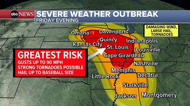
The severe weather begins in the Midwest on Friday evening.
Residents from Davenport, Iowa, to Peoria, Illinois, and St. Louis to Memphis, Tennessee, are in the bull's-eye for strong tornadoes. Destructive winds from thunderstorms could reach 90 mph and hail could be as large as baseballs.
On Saturday, the highest threat for tornadoes moves into the Deep South, focusing on eastern Louisiana, Mississippi, Alabama and the western Florida Panhandle.
In a rare warning, the highest risk level for severe weather/tornadoes has been issued from Jackson, Mississippi, to Birmingham, Alabama, where Gov. Kay Ivey issued a state of emergency. Those in the area should brace for numerous, significant tornadoes, some of which could be long-track and potentially violent.
The most dangerous tornado threat will begin in Louisiana and Mississippi late Saturday morning and the early afternoon. The threat spreads into Alabama in the late afternoon and evening and then reaches Florida and Georgia late Saturday night.
Destructive winds up to 80 mph and large hail are also in the forecast.
The severe storms will cover a large area, spreading as far north as Atlanta and Nashville, Tennessee.
On Sunday, the severe storms will be weaker as they target the East Coast from Florida to Pennsylvania.
The tornado threat will be focused on the Carolinas and Georgia in the afternoon.
Storms with the potential for damaging winds will reach the Northeast by the evening and last through early Monday morning.
Copyright © 2025, ABC Audio. All rights reserved.